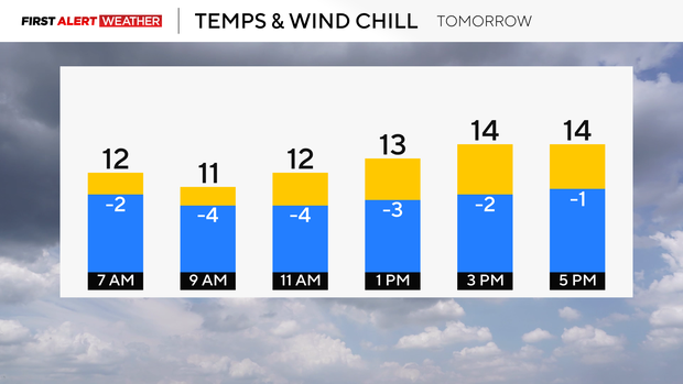
The National Weather Service issued a Winter Storm Warning for areas of the Pittsburgh region along and south of I‑70 (with Winter Weather Advisories northward) as a band of heavier snow moves in Saturday into Sunday; most of the region is forecast to receive 2–4 inches (3–5 inches in Pittsburgh, 5–10 inches on ridges) with snow tapering around midnight and a follow-up arctic shot producing single‑digit lows and subzero wind chills with gusts to 15–20 mph. PennDOT has reduced speed limits to 45 mph on major interstates and urged motorists to avoid unnecessary travel while Allegheny County mobilized two dozen plows and more than 9,000 tons of salt; lake‑effect bands are expected Sunday into Monday (I‑80 to Route 422 corridors and Mercer/Venango), raising the risk of locally higher totals, reduced visibility and continued roadway hazards through the event.
The National Weather Service issued a Winter Storm Warning for parts of the Pittsburgh region along and south of I‑70 with Winter Weather Advisories northward; the forecast calls for nearly all areas to receive 2–4 inches of snow, 3–5 inches in Pittsburgh and 5–10 inches on ridges, with lake‑effect bands expected to increase coverage Sunday into Monday (notably I‑80 to Route 422 corridors and Mercer/Venango counties). Temperatures will fall into single digits with wind chills below zero and gusts to 15–20 mph after snow tapers late Saturday night, increasing the risk of slick surfaces and reduced visibility. PennDOT preemptively reduced speed limits to 45 mph on major interstates (I‑70, I‑79, I‑376, I‑279, I‑579 and select corridor segments) and Allegheny County mobilized roughly two dozen plows and more than 9,000 tons of salt, while officials caution that treated roadways will not be completely free of ice. Given the modest market impact score (0.05) and neutral sentiment, the event appears regionally disruptive but likely transitory unless lake‑effect bands materially increase accumulations or extend duration.
AI-powered research, real-time alerts, and portfolio analytics for institutional investors.
Request DemoOverall Sentiment
neutral
Sentiment Score
0.00
