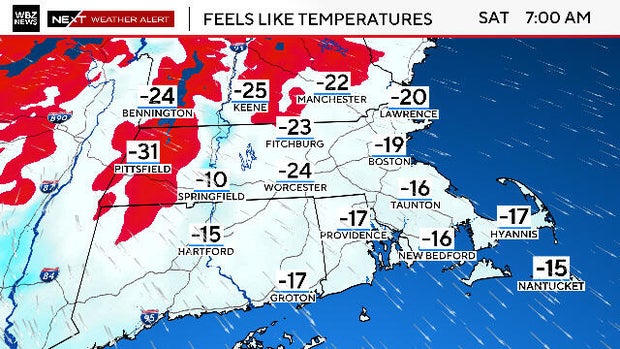
A major winter system and Arctic air mass will bring widespread 10–20 inches of snow to southern New England (including Boston) with peak impacts roughly 5 p.m. Sunday through 5 a.m. Monday and potential localized "jackpot" zones of 18–24+ inches where cold, fluffy snow stacks up; coastal mixing could reduce totals in some locations. The National Weather Service has issued broad watches/warnings across a ~2,000-mile swath, with hazardous travel expected (worst ~7 p.m.–7 a.m.), a modest risk of airport shutdowns and localized power outages, but limited concern for sustained blizzard-force winds.
Market structure: Heavy New England snow (10–20" widespread, localized 18–24+" risk) creates clear short-term winners—retailers for winter supplies (HD, LOW), backup-generator makers (GNRC), and diesel/heating-fuel suppliers—and losers: regional airlines (AAL, DAL) and ground-transport/logistics (UPS, FDX) from cancellations/delays. Natural-gas and heating-oil demand should spike for 1–10 days, pressuring front-month NG/HO futures and raising short-term electricity prices in ISO-NE; limited wind reduces sustained blizzard risk, so systemic power outages are lower probability.
Risk assessment: Tail risks include an unexpected coastal warm-front that turns heavy snow to ice/rain—this would cut snowfall but increase infrastructure damage and insurance/claims, amplifying losses for property insurers (PGR, ALL). Immediate window is days (weekend to Monday) for travel/logistics disruption; weeks for retail sales and generator order fulfillment; quarters for any durable-capex lift at manufacturers. Hidden dependency: inventory/supply-chain constraints (GNRC lead times, retailer stock) can delay revenue recognition by 4–12 weeks. Catalysts: National Weather Service updates, FAA cancelations, and ISO-NE real-time price spikes will accelerate moves.
Trade implications: Tactical trades favor short-duration, event-driven positions: buy short-dated NG/HO calls (2–4 week expirations) to capture heating demand; establish a 1–2% portfolio long in GNRC (3-month calls) and 0.5–1% tactical longs in HD/LOW (near-term strength in winter goods). Short 0.5–1% positions in AAL or DAL via 2-week put spreads ahead of the storm window; stash 3–5% in short-duration Treasuries (BIL/SHY) for weekend risk-off liquidity.
Contrarian angles: Consensus may overprice generator demand—forecasts note low powerline outage risk and very fluffy snow that doesn’t topple lines, so GNRC upside is real but capped if outages remain low. Historical parallels (cold snaps 2015, 2018) show sharp but short-lived spikes in NG and retailers; avoid taking multi-quarter directional bets absent persistent cold.
AI-powered research, real-time alerts, and portfolio analytics for institutional investors.
Request DemoOverall Sentiment
mildly negative
Sentiment Score
-0.25
