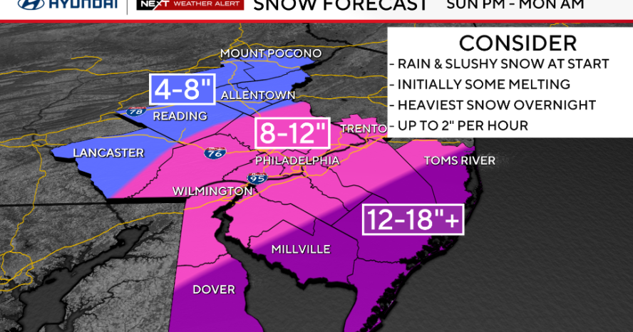
A rapidly intensifying coastal nor'easter (potential "bomb cyclone") is forecast to impact the Philadelphia metro and Jersey Shore from Sunday afternoon into Monday, with heaviest snow from ~9 p.m. Sunday to 6 a.m. Monday. Snow totals are projected at roughly 8–12 inches in Philadelphia and the I‑95 corridor, 4–8 inches in the Lehigh Valley/Berks, and 12–18+ inches along the coast; blizzard, winter storm, and coastal flood watches/warnings are in effect and officials warn of whiteout conditions, high winds, coastal flooding and potential power outages that could disrupt transportation, utilities and coastal infrastructure.
Market structure: Winners in the next 0–14 days are regional energy suppliers and spot natural gas (NYMEX NG) as heating demand and emergency generation lift load; home-improvement retailers (HD, LOW) should see incremental sales in snow-clearing SKUs (expect a 2–6% weekly comp lift in affected stores). Losers are short-duration transport/exposure names (airlines AAL, DAL; parcel FDX, UPS) from cancellations and route disruption, and small municipal budgets in NJ/PA that may face >$10–50m line-item cleanup costs per county. Coastal flooding and high winds create transient pricing power for rental/contractor services while utilities face both higher volumetric revenue and outage-repair cost volatility.
Risk assessment: Tail risks include prolonged multi-day outages, major transmission damage, or a slower storm track that expands insurance-loss estimates into the hundreds of millions regionally — insurers and muni credits could see claims recognition over quarters. Time horizons split: operational/trading impacts (days), insurance/reserve recognition (weeks–months), and infrastructure/regulatory responses (quarters). Hidden dependencies: fuel logistics (diesel for plows/generators) and port/truck chokepoints can cascade to retail restocking delays; a model-shift offshore would negate most plays quickly. Catalysts to watch: model track updates in 12–36 hours, ISO-NE/ PJM real-time price spikes, and airline cancellation notices.
Trade implications: Direct short-term plays: long short-dated NG exposure (calls or spreads), long-weekly calls on HD/LOW, and protective puts on AAL/DAL; rotate underweight into transportation and overweight consumer discretionary workwear/home goods for 1–2 week windows. Options: favor 7–14 day call spreads on NG to cap premium, and 7–14 day ATM calls on HD/LOW; buy 7–14 day 5–10% OTM puts on AAL/DAL for tail hedges. Entry: initiate within 24 hours of final storm-track confirmation; exit within 7–14 days or on hit targets.
Contrarian angles: The consensus risk-off on utilities may be overdone — regulated utilities (PEG, PPL) often recover storm O&M via trackers; shorting them for a knee-jerk reaction can be costly. Historical parallel: 2018 NE bomb cyclone produced +15–25% intraday gas spikes and modest multi-day retail upticks, not prolonged demand shifts. Unintended consequence: severe stockouts at retailers could cap upside and raise working-capital needs; insurers may re-price coastal risks, creating 3–6 month sector idiosyncratic dispersion.
AI-powered research, real-time alerts, and portfolio analytics for institutional investors.
Request DemoOverall Sentiment
mildly negative
Sentiment Score
-0.25
